Central Meteorological Observatory: The cold wave weather will end the high temperature in the south, and the strong precipitation in Sichuan, Shaanxi and Henan will be weakened.
CCTV News:According to the website of the Central Meteorological Observatory, there was a strong wind cooling in the northern region: due to the influence of cold air, the temperature dropped by 6 ~ 10℃ in the northeast, North China, Huanghuai, northern Jianghuai, Jianghan and northeastern Sichuan at 05: 00 today, and dropped by 12 ~ 18℃ in northern North China and eastern Heilongjiang, central and eastern Jilin and central Liaoning. There were 6 ~ 8 gusts and 9 ~ 11 local gusts in some of the above areas yesterday. This morning, the temperature 0℃ line is located in the north of Shanxi, the north of Hebei and the north of Liaoning.
There is heavy rainfall in Sichuan, Shaanxi, Henan, Shandong and other places: from 08: 00 yesterday to 06: 00 today, heavy rain or rainstorm occurred in northeastern Sichuan, central and southern Shaanxi, northwestern Hubei, central and western Henan, northern Jiangsu and Anhui, central and northern Shandong and peninsula, southern Tianjin and southern Guangdong Leizhou Peninsula, northeastern Hainan Island and other places, and heavy rains occurred in Guangyuan, Bazhong, Suining, Shaanxi, Hanzhong, Ankang, Shangluo, Shiyan, Shandong, Zibo, Weifang and other places.
Cold wave weather will end the high temperature in the south
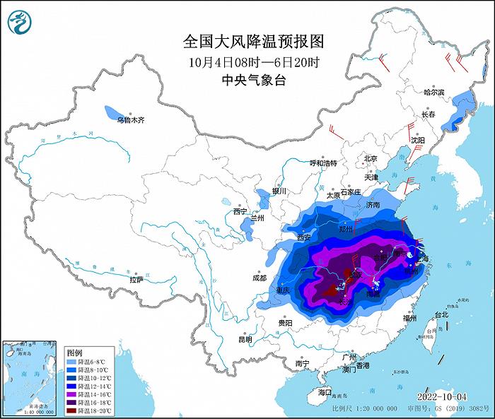
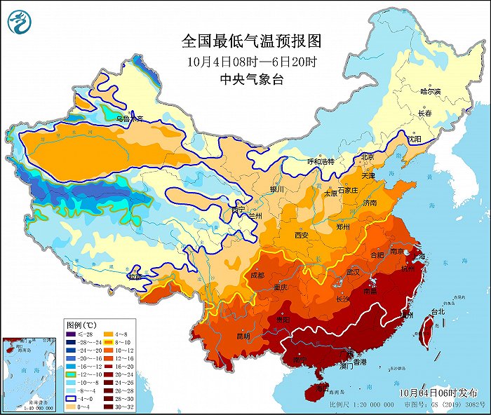
Affected by strong cold air, it is estimated that from 08: 00 on October 4 to 20: 00 on October 6, the temperature in the southeast of northwest China, southern North China, Huanghuai, Jianghuai, Jianghan, eastern Southwest China and most parts of the south of the Yangtze River will drop by 6 ~ 10℃ successively. Among them, the temperature in parts of southern Huanghuai, Jianghuai, Jianghan and northern Jiangnan will drop by 12 ~ 16℃, and the local temperature drop can reach more than 18℃. On the morning of 6th to 7th, the lowest temperature 0℃ line will be located in the northern part of North China to central Liaoning, and the lowest temperature 10℃ line will be located in the northeast of Sichuan, central Hubei, southern Henan to northern Jiangsu and Anhui. There will be 4~6 winds in the Yangtze River basin and its north, and gusts in high altitude areas and rivers and lakes can reach 7~8. There will be 7 ~ 9 strong winds in the northern and eastern seas of China, with gusts of 10~11. The Central Meteorological Observatory continued to issue a blue warning of cold wave and a yellow warning of strong wind at sea at 06: 00 on October 4.
Due to the influence of cold air going south, the high temperature range in the southern region is obviously reduced and the intensity is weakened. However, it is estimated that there will still be high temperature above 35℃ in southern Zhejiang, most of Jiangxi, Fujian, north-central and eastern Guangdong, and northeastern Guangxi during the day on October 4, among which the high temperature in parts of south-central Jiangxi, most of Fujian and northern Guangdong can reach above 37℃. After 5 days, this high temperature process ended. In addition, in the next 10 days, there will still be no obvious rainfall in most parts of the south of the Yangtze River and northern South China, and the meteorological drought will continue.
In addition, it is expected that a new round of cold air will affect most parts of the central and eastern regions from August 8 to 10, and the temperature will drop by 4 ~ 6 C, and some areas will be 8 ~ 10 C.
Strong precipitation in Sichuan, Shaanxi, Henan and other places has weakened
Due to the reduced range and intensity of heavy precipitation, the Central Meteorological Observatory lifted the blue rainstorm warning at 06: 00 on October 4. However, it is estimated that there will still be moderate to heavy rain in the northeastern Sichuan Basin, southwestern Shaanxi, Huanghuai, Jianghuai and Jianghan from October 4 to 6, and there will be heavy rain in some areas.
Specific forecast for the next three days
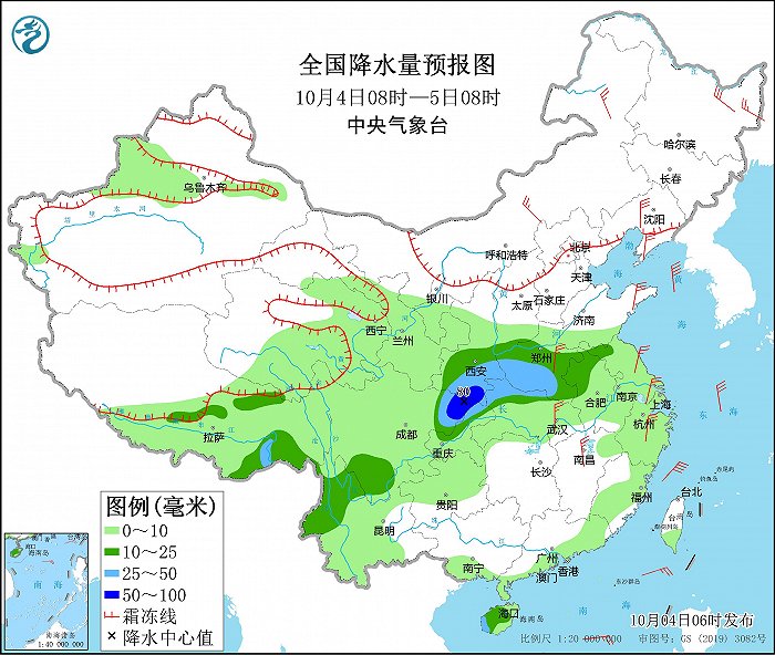
From 08: 00 on October 4 to 08: 00 on October 5, there were moderate to heavy rains in parts of southeastern Tibet, northwestern Yunnan, northeastern and southern Sichuan, northern Chongqing, southwestern Shaanxi, most of Henan, northern Hubei, northern Jiangsu and Anhui, and most of Hainan Island. Among them, there were heavy rains (50-80 mm) in southwestern Shaanxi and northeastern Sichuan Basin. There are 4 ~ 6 winds in parts of central and eastern Inner Mongolia, Heilongjiang, Liaoning, Shandong Peninsula, eastern and southern Henan, central and southern Jiangsu, eastern Hubei, northwestern Jiangxi and Zhejiang, with gusts of 7 ~ 8 (see Figure 3). The Bohai Sea, the Bohai Strait, the northern and central waters of the Yellow Sea, most of the East China Sea and the Taiwan Province Strait will have strong winds of 7-9 and gusts of 10-11.
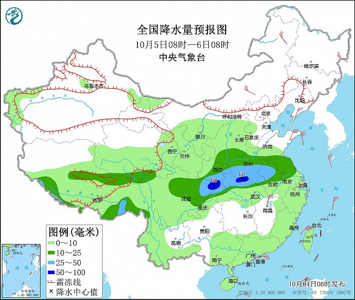
From 08: 00 on October 5 to 08: 00 on October 6, there were moderate to heavy rains in parts of northern and southern Tibet, southern Qinghai, south-central Shaanxi, central and western Huanghuai, most of Jianghuai, northern Jianghan, and most of Sichuan Basin, with local heavy rain (50 ~ 60 mm). There are 4 ~ 6 winds in parts of northeastern and central Inner Mongolia, eastern Heilongjiang, Liaodong Peninsula, Shandong Peninsula, northwestern Jiangxi and northern Zhejiang (see Figure 4). The Bohai Strait, most of the Yellow Sea, most of the East China Sea, the Taiwan Province Strait, the bashi channel and the northeastern South China Sea will have winds of 6-7 and gusts of 8, among which the winds in parts of the Taiwan Province Strait can reach 8 and gusts of 9.
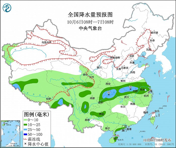
From 08: 00 on October 6 to 08: 00 on October 7, there were moderate to heavy rains in parts of southwestern and southeastern Tibet, southern Qinghai, southern Huanghuai, most of Jianghuai, most of Jianghan, south-central Sichuan Plateau, northeastern Sichuan Basin, most of Chongqing, and eastern Hainan Island, and there were local heavy rains. There are 4 ~ 5 winds in parts of central Inner Mongolia, Liaodong Peninsula and Shandong Peninsula (see Figure 5). There will be 6-7 winds with gusts of 8 in the eastern Yellow Sea, the northern East China Sea, the Taiwan Province Strait, the bashi channel and the northeastern South China Sea.